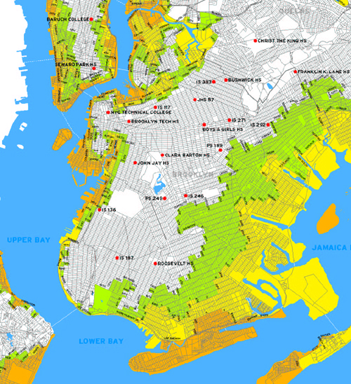
In honor of today’s start of hurricane season, we present what is becoming an annual tradition here at GL: a look at what might happen to Brooklyn and all of New York City, courtesy of the Office of Emergency Management‘s hurricane evacuation map. Please note exactly how much of Brooklyn will be underwater in the (admittedly unlikely) event of a monster hurricane. Up to one-third of our fair borough could end up as rowboat land. Storm surges could be up to 30 feet in some parts of the borough. That’s about three stories worth of water. You will note on the map that all of Manhattan south of Canal Street in under water.
in the map, orange areas get nailed in any sort of hurricane. Yellow in a Category Two and Green (the really scary stuff) in a Category 3 or 4. If a Category 5 strikes New York, we suppose that we become a part of the history books under Global Warming and that future generations in the desert around Minneapolis will read about what happened to us and shake their heads. Anyone that wants to read a riveting account of what a hurricane would do to New York, you should check out Aaron Naparstek‘s superb article in the New York Press in July 05. The devastation he outlines makes could make the damage to New Orleans look minor, if only because the scope of the flooding in New York will be so much larger.

3 responses so far ↓
1 DebK // Jun 1, 2008 at 1:46 pm
NYC has had plenty of hurricanes but I can’t remember Coney Island or lower Manhattan in any way ‘nailed’.
2 gordon // Jun 2, 2008 at 5:48 pm
The image clicks through to Flickr where the image is marked as private and not displayed. Would love to see some close-ups or a larger version of the map…
3 Hurricane Jane // Jun 2, 2008 at 8:36 pm
DebK,
You must not have been alive in 1893. That’s the last real direct hit the city has seen. 1821 was quite something as well. 1938 would have really taken out the city had it landed just 50 miles to the west.
Those other ’50s and ’80s “hurricanes” that you probably do remember were tropical storms and nor’easters and they weren’t really direct hits on the city.